


- Bayfield County -
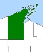 Bayfield county is situated in the northernmost tier of Wisconsin counties and include Sand, York, Eagle and Raspberry Islands of the Apostle Island group. The remaining islands belong to
Ashland county. Bayfield county is bounded on the north by Lake Superior, south by Sawyer county, southwest by
Washburn county, on the east by Ashland county, and on the west by Douglas county. The county was created in 1845 and organized in 1850, originally being
named La Pointe. A portion was split off in 1854 for Douglas county and, in 1860, another portion was split off for Ashland county. The remainder
was given the new name "Bayfield," after Henry Bayfield, in 1866. The early county records were destroyed by fire in 1874. Bayfield county has a total
of 2,042 square miles, 564 square miles of it being water. The county seat, and largest city, is Washburn.
Bayfield county is situated in the northernmost tier of Wisconsin counties and include Sand, York, Eagle and Raspberry Islands of the Apostle Island group. The remaining islands belong to
Ashland county. Bayfield county is bounded on the north by Lake Superior, south by Sawyer county, southwest by
Washburn county, on the east by Ashland county, and on the west by Douglas county. The county was created in 1845 and organized in 1850, originally being
named La Pointe. A portion was split off in 1854 for Douglas county and, in 1860, another portion was split off for Ashland county. The remainder
was given the new name "Bayfield," after Henry Bayfield, in 1866. The early county records were destroyed by fire in 1874. Bayfield county has a total
of 2,042 square miles, 564 square miles of it being water. The county seat, and largest city, is Washburn.