

- Marquette County -
Mining
(Aside from Mine Inspectors Reports, mining accidents will be found on our Disasters page.)
 In 1844 a government surveying party was running the east line of Township 47 N, Range 27 W when the needle of their magnetic compass began to jitter and
dip wildly. Comparing it with their solar compass, an invention of William A. Burt, showed just how wildly the magnetic compass was behaving. Burt's report
noted that "Spathetic and hematite iron ore abound on this line."
In 1844 a government surveying party was running the east line of Township 47 N, Range 27 W when the needle of their magnetic compass began to jitter and
dip wildly. Comparing it with their solar compass, an invention of William A. Burt, showed just how wildly the magnetic compass was behaving. Burt's report
noted that "Spathetic and hematite iron ore abound on this line."
With the release of his report the Marquette region came to life. The Jackson Mining Company was organized in 1845 at Jackson, Michigan, with interests in copper mining. Their focus soon changed to iron ore and, convinced that iron ore was present in large quantities, secured the "Jackson location." The company was the first to break ground for actual mining of iron ore on the Marquette range and the mining town of Negaunee sprang up nearby. Clusters of shacks sprang up around holes in the ground, and every group of shacks was a "location." Towns such as Republic, Humbolt, Austin and Skandia sprang from them. The city of Ispheming grew from a mish-mash of these locations. Through the years there were roughly 125 mines on the Marquette Range. Nearly all are gone now, and a few are forgotten to history.
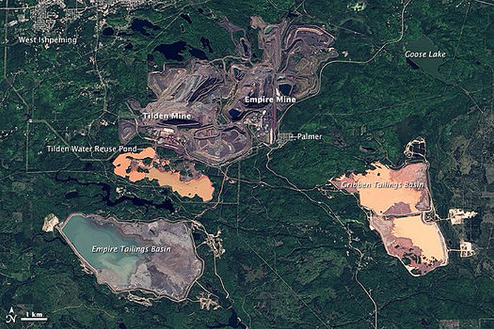
 In 2010 only the Tilden and Empire mines still existed as active mines in Marquette county; both being so
immense that they can be seen from space. Cliffs Natural Resources,
owners of the massive Empire mine, a mile wide and 1,200 feet deep, has been idled for months at a time on several occassions and, in 2016, announced
its closing. This leaves only the nearby Tilden mine, also owned by Cliffs Natural Resources, as the last operating iron ore mine in Michigan.
In 2010 only the Tilden and Empire mines still existed as active mines in Marquette county; both being so
immense that they can be seen from space. Cliffs Natural Resources,
owners of the massive Empire mine, a mile wide and 1,200 feet deep, has been idled for months at a time on several occassions and, in 2016, announced
its closing. This leaves only the nearby Tilden mine, also owned by Cliffs Natural Resources, as the last operating iron ore mine in Michigan.
The following list of mines was taken from the 2010 Annual Report of Mine Inspectors, Marquette County, MI:
Abandoned Mines and Pits Inspected 2010.
|
|
Additional Mine Information
Republic Mine: opened in 1871 as an underground mine and operated by the Republic Iron Company until 1913. Became property of the Cleveland-Cliffs Iron Company in 1914 and remained in operation as an underground mine until the late 1920's when the mine was closed. The depth at this time was 2910 feet. Re-opened in the 1950's as an open pit mine. The Republic mine site covered four square miles when permanently closed in 1981. The 600 foot deep pit was allowed to flood and, after being cleaned up, the tailings basin was designated as a wetlands preserve.
